Cairngorm Loop - A serious challenge
A relentless self-supported mountain bike event through some of the most remote parts of the Cairngorms.
Posted: Wed 03 May, 2017, 12:32
- The Start
- The Route - Six stages
- Following Wind - Blair Atholl to Loch Morlich
- Up onto the Plateau - Loch Morlich to Derry Lodge
- Riding into the Dark - Derry Lodge to Aviemore
- Way out East - Aviemore to Tomintoul
- Back into the Wind - Tomintoul to Braemar
- The Final Push - Braemar to Blair Atholl
The Start
After a long winter of preparation, it was great to be at the start. It's difficult to get ready for something you have no experience of, but my approach had been on three fronts. The bike, the gear and my fitness. The bike had been overhauled from an off-the-shelf Rockhopper to something a bit more solid, with air forks, upgraded 1x11 gears and a stronger bottom bracket. The gear was packed into a mixture of bikepacking bags which were actually all bursting at the seams. My fitness was as good as it was going to be i.e. not great. I'd managed some four hour rides every other weekend, but that was about it. Not exactly Loop-ready, but as ready as I was going to be.
One of the advantages of the group start is simply to see what sort of people with what sort of kit are attempting this challenge. It was with some interest that I surveyed the bike hardware on show at the start. Of 26 entrants, 18 had turned up. There as a lot of full-sus, a lot of carbon and a lot of titanium. People were riding Jones, Cannondale Lefties and Shand. Only one other rider had as much kit as me, most were going for the super-fast light option.
Having chatted to some of the other starters, there were clearly some very serious riders, probably verging on what you might call athletes. A surprising numberhad tried it before, and were returning to finish it or improve their time. Whilst my goal was just to finish, the vibe at the start was much more about the race. As I was to realise more fully over the weekend, everyone had made their own risk/comfort/speed calculation and packed accordindly, putting me firmly in the heavyweight end of the spectrum. I was certainly not a contender, but definitely hoping to be a finisher.
Steve gave us the two minute warning and then we were off at 10am sharp. After a couple of ugly gear crunches from me, we spun away up the hill and my Cairngorm Loop had finally started.
The Route
The Loop is 186 miles. The vast majority is off-road over a huge variety of tracks and trails, over grass, bouldery paths, gravel and sheep trails. One of the delights of the route is that the landscape is ever changing and takes you to some truly special places, like the Fords of A'an or the Bealach Dearg. There are a number of fords which were an unexpected challenge for me, particularly in the dark. Riding at night was certainly not my plan, but it's what ended up happening. The route is downloadable via the website in GPX format. Navigation is not supposed to be part of the challenge, but I have to confess that I was lost on numerous occasions, but mostly down to my GPS device. For some reason, my route lost a lot of detail and often only had a waypoint every half a mile meaning any twists and turns (in a forest for example) are lost as the device only shows the rough direction. I am pretty sure most other riders did not have the same problem. Without my two paper maps, I would not have finished the route.
I broke the ride down into six stages of roughly equal effort. My goal was to do three stages, sleep and then do the next three. As it turned out, this was hugely optimistic of me, but it was worth having a target to push on for. Just by way of comparison, the record for the whole route is 18 hours. My impression from seeing the 2017 finishers is that the super light riders did not finish. So there is a sweet-spot between making sure you finish and not slowing yourself down with too much. After overall fitness, this is probably the biggest factor that will determine completion and overall time.
Here is the zoomable map showing using my actual GPX data tracks, including all the sections where I went the wrong way or got lost (zoom in on Glen Feshie). My route runs from black at the start to light green at the end.
Following Wind - Blair Atholl to Loch Morlich
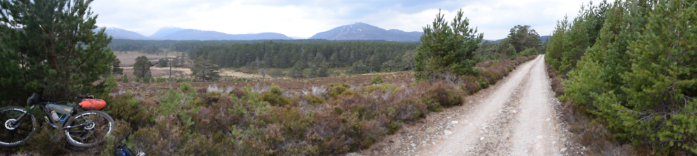
The first stage of the route would take us through the southern Cairngorms. For me it was a chance to find my pace, enjoy landscapes that was new to me and make sure everything was hanging together on the bike. It did not take long to figure out that my GPS route finder was having issues. At one point I had to double back thinking I had missed a side track. But it was just interpolating via points that were way too far apart.
As we climbed up away from the A9, we moved onto gravel and the pack very quickly stretched out until those at the front were out of site. We had strong southerly winds at our backs which made the going deceptively easy. Once the route cut off onto the path around Loch an Duin, I was off and pushing the bike for the first time. My first mechanical, which was not a complete surprise, happened just before we began our descent. The pedal crank arm screw had been coming loose during my training and it happened again. I quickly tightened it and was back on my way.
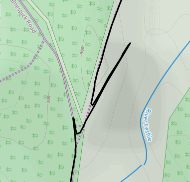 Much of the downhill towards Glen Tromie was on road and with the following wind I was travelling as fast as I dared and briefly passed one of the other riders. I had to stop to hook my GPS up to the battery and he then flew past me again. The actual navigation issues became more apparent once the route started to weave through forest trails towards Glen Feshie. This image on the right, taken from my actual GPS track, shows the typical sorts of problems - two wrong turns before finding the correct route.
Before too long we were winding our way through Rothiemurchus forest, the weather was getting better and there were plenty of walkers and bikers out enjoying the increasing fine weather. Of course, I took another wrong turn and went over a mile before deciding the retrace my steps. Once finished the route, I looked at heart my rate data for the first 8 hours of day one. It is interesting to see when my peak heart rate occurred. On a huge climb? No. It was as I realised I was getting lost and going away from my intended route. Interesting to see how your body reacts to both physical and psychological stresses.
Back on track, with the sun shining and snow on the hills, it felt like a particularly good place to be. Loch Morlich soon came into view and I reached the Loch Morlich Cafe for a much needed break. Completing the first stage felt like a really big milestone. No major issues. The GPS problems I felt I could handle by using my maps when necessary and was really never an issue when out on open ground, which is what I was heading into. The coke and carrot cake at the cafe was magnificent, where I also the the chance to grab some more cereal bars before heading into more remote areas.
In terms of time, I was a good 2 hours behind where I had (naively) hoped to be. No big issue as it was only mid-afternoon, but it raised a question mark about where I would be when night fell.


Up onto the Plateau - Loch Morlich to Derry Lodge
After passing the swanky new Glenmore Lodge, the route passed the beguiling An Lochan Uaine, which seemed to have an emerald green glow in the bright sunshine of Ryvoan Pass. Just after that as the track wound upwards I ran into Colin again, a fellow rider who had also packed plenty, and we had a laugh about the fact we had both decided to carry a stove. As I moved on ahead I called behind to say I'd probably meet him again after the next time I got lost, but that was actually the last time I saw him. A stove, as it turned out for me, was a complete essential given the cold and ground conditions. Better to be slightly slower but able deal with anything unexpected.
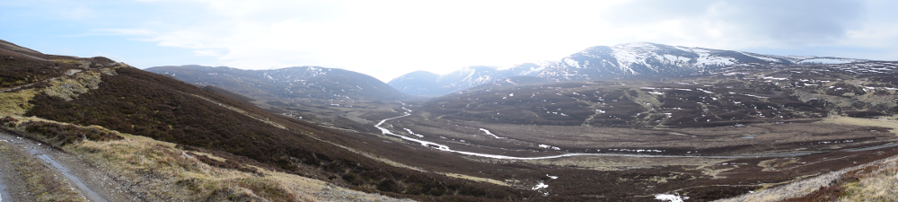
The climb up to Rynack More pass was over 500m and it was a slog. It was late afternoon by this stage and not the typical time of day to be heading up, a point not lost on the walkers who coming down. One helpfully commented that I had a long way to go to catch the others. Although I was short of time I was also determined to enjoy where I was, take a few photographs and some good breaks. Despite my delays, nobody caught me before I reached the plateau. The path itself was excellent, fairly flat and very rideable but with banks for snow every 30 metres or so it was necessary to jump off and push through knee-high snow. The views to the back of Cairn Gorm were breathtaking, the sunlight slanting through onto snow covered tops. It was still winter up here.
Before long the path dropped down on an undulating and often rocky footpath. By 7pm I had reached the Fords of Avon (A'an), where the foot of the glen still stands at 700m above sea level and the Avon can be crossed. A small bothy looked very inviting and there was one other tent pitched at this magnificent spot, where ancient glaciers seem to have converged and crossed course somehow leaving cross-shaped glens that stretch to the north, south, east and west. With time ticking on and the first hint of evening gloom, I was on my way and managed to cross the river without too much trouble. Ahead of me was a gentle but boulder strewn climb to a water shed at the head of Laraig an Laoigh. I glimpsed another rider as his profile broke the skyline a good 45 minutes ahead of me. Until then I had been continually cold on my exposed exterior but balanced by being warm from within, but as my progress slowed the cold and the temperate dropped, the cold won out and I had to dig out my Goretex waterproof.
Another walker appeared coming the other way at the top of the glen, just before the drop into Glen Derry. He was all kitted up and obviously expecting to camp out. He had passed some other riders ahead and who had been slightly "glazed", maybe pushing too hard. I never caught them in the end, or found out who he had met, but in the end everyone made it back one way or another. I carried on abd began the decent down into Glen Derry which could not be more different to the raised glen from which I had just emerged. Glen Derry is wide and flat-bottomed with occasional Scot's pines and River Derry meandering through. As I dropped, the path became better and better, less rocks and more smooth grass.


Riding into the Dark - Derry Lodge to Aviemore
After a pleasingly simply ride through the lower reaches of Glen Derry I finally emerged at the Linn of Dee in the gather gloom of fading evening light. Turning west, my daily ride time was now around 10 hours, much longer than I had done in any training. Just before the forest opened onto to Dee valley I realised I had actually riden into large herd of deer. In the half light, they observed me cautiously but were only a few metres away and obviously unused to people wandering about at this time of night. They held their nerve though and stayed close as I rode through them and out along the Dee.
In truth, I was a full stage behind where I had hoped to be. At this point I had hoped to be near Aviemore and ready to bed down for the night. Instead I had some decisions to make. I knew I had another hour or so of daylight left and night riding was not something I had planned on. My bike light was excellent for commuting, but had never been tried in the wilds, and my best guess was that it had 2 hours of battery power. This is the most I had ever used it before recharging. Either I stopped before the connector back to Glen Feshie or I pushed on over the pass at night.
It's funny what motivates you, particularly when cold and tired. In my head was a vision of waking up in the morning and making my porridge on the stove, for which I needed milk. That goal was a key factor that drove me on over the pass, so that I could buy milk in Aviemore and have my perfect pre-ride breakfast. It seems comical now, but this was a small but important objective that in the end made me decide to push on to Glen Feshie. It was completely dark as the rack began to climb and I spotted Howard, another experienced rider, who had pitched up and decided to stop for the night. Soon afterwards I put my light on for the first time which only amplified the complete darkness around me.
I estimated it would be take me 2 hours over the connector, by which time I would be back down in good tent-pitching territory at least, or possibly all the way to the road, allowing me to trundle into Aviemore. As I followed the path up the Geldie Burn the wind increased and my tiredness really kicked in. Pushing the bike over sections of snow was relentless, making the path impossible to ride and needing huge efforts to physically haul the laden bike up out of gulleys and streams. Checking the map, I tried to estimate where I was and after some time had my first real fix, a thundering waterfall which I could hear long before I had to traverse it. The crossing was over a very narrow metal bridge constructed perhaps by the army at some point. With noise, the very low knee-high barrier and the torrents rushing beneath I did begin the question the wisdom of my decision make the push to Glen Feshie. Eventually, the route began to drop, after more than 2 hours. My light was going strong but my concern was growing that I would cut out leaving me no chance to find a pitch, never mind put up the tent.
As I turned finally to the north and back into the trees, I felt myself getting too hot so I tied my waterproof around my waist, unwilling to take the time to force it back into the saddle bag. Ahead of me however, was what turned out to be the most difficult part of the Loop. In total, I managed progressed perhaps 2 miles but covered over 4 miles, fording the River Feshie perhaps six times. The River Feshie here is powerful and often deep, my bike light illuminating the river bottom as best it could, helping me to steer a course away from the depths. When crossing a river with a bike, anything more than axle high and the drag of the bike attempts to twist it out of your grip. More than once, when up to my waist, the sheering flow pulled the bike away and all I could do was to hold on until it settled back down pointing straight upstream, perpendicular to the direction I was going.
The reasons for my multiple crossings were numerous. The complete darkness meant I missed probably obvious turn offs to side-paths that might have prevented a crossing. My GPS was of course only giving me a very vague direction and virtually useless when winding through trees. The main factor however was that the floods of 2015 have completely changed the course of the river, meaning that the OS maps are wrong and I expect also the GPX Loop route is also inaccurate here as it was recorded pre-floods. I did not know this at the time and was increasingly confused about why I was having to cross the river. As I stood again checking my map I grew cold and decided to put my waterproof back on, but it was gone, swept away in a crossing or as I dragged through some bushes. Not good.
I finally gave up and decided to camp when I felt 100% lost. My confusion was so complete that I thought the river was flowing the wrong way, having become disorientated I thought I was going north when in fact I was going back south, where I had come. With the advent of GPS and mobiles, we are very rarely lost any more. But this was pretty close. Exasperated, confused, frustrated and exhausted I pulled myself up out of the river and said "F*** it, I'm camping here". By sheer good fortune, it was perfect spot with soft flat ground. Incredibly and to my eternal gratitude, the light was still working, at 2am, some 4 hours later. I used it to pitch the tent, make my food and sort out my kit before turning in at 3am, alarm set for 7:30.
It was a cold night, but I think I slept for a couple of hours. The alarm woke me, so I was definitely asleep then. In the cold light of morning my late night confusion was suddenly evaporated and I could clearly see where I was and where I needed to go. There was not a soul around, only a goose by the shore and the sun was trying to come through. It was exactly the sort of spot I would have chosen to camp at in broad day light, all the more miraculous that I had ended up here by pure luck. I skipped breakfast, hoping I might have time for a quick fry-up in Aviemore. Now that was a breakfast motivation!
I saddled up and headed off in the early morning light. The devastation caused by the floods was incredible and required a couple more significant detours but no fording of the Feshie. Before long I was back on rideable trails, then on road and after a few very pleasant miles I was finally in Aviemore.


Way out East - Aviemore to Tomintoul
Arriving in Aviemore on a Sunday morning, with the early moring buzz of activity, felt pretty satifsying. I spotted another Loop rider (on the Cannondale Lefty) who appeared to be going nowhere fast. I think he had pulled out, because he was still in town as I left almost an hour later. First stop for me was to pick up a new waterproof. Once I got that sorted it was into a cafe to order breakfast and send a couple of messages to let everyone know I was safe and well. A bacon and egg roll never tasted so good and was gone in no time. I could have ordered another but remembered from my Hebridean Way experience that it's better to eat a little often rather than splurge. My last stop was to restock my supply of cereal bars and chocolate for out on route, and then I was back in the saddle and off to rejoin the route. Just as I rejoined, I saw Howard pull off, probably to the restaurant by the side of the trail. Both our strategies - sleep first and ride the pass in the morning or ride the pass at night and sleep later - had resulted in us being a precisely the same spot. However I reckon Howard probably had slightly more sleep than me, although I did not get a chance to ask him and never saw him again. I rejoined the Loop route and headed off towards the Abernethy Forest.
This section of the Loop as probably the most straightforward in terms of terrain and navigation. I really enjoyed it even though there were plenty of big climbs, the landscape is open and the views to the south were incredible. If there are any easy miles on the Cairngorm Loop, this is probably some of the easiest. It was 26 miles to Tomintoul and it took me just over 4 hours. Even on the most wide open sections, I never saw anyone behind me, which surprised me given I was not travelling that fast and I'd seen a couple of others in Aviemore. On the moors around Dorback Lodge I saw some birds I had never seen before. Black bodies with white beneath their wings. I have still not identified them.
Tomintoul was the most northerly point in the loop, after that is was all homeward bound, so it felt like another big milestone. I found a cafe and ordered soup, coke and some cake. I told the owner I was heading for Blair Atholl, off-road, and he was (rightly) skeptical about my chances of it that far in a day. It was three o'clock when I rolled out of Tomintoul and headed south down Glen Avon (A'an), through which flows the same water I had passed almost 24 hours before high in the heart of the Cairngorms.

Back into the Wind - Tomintoul to Braemar
The first section south to Glen Builg should have been easy miles. The route is on road to begin with and trail for a very long way. However it did not work out that way. The wind that so kindly blown me north was now blowing just as hard but against me. The further down the glen I rode, the stronger it got as though it was funnelling through the narrowing sides of the glen. To put it in perspective, I was cycling on perfectly rideable gravel tracks and the wind was so intense I could hear nothing except it's roaring in my ears, and my progress had slowed to my spinniest gear. I was crawling along, much to my frustration, and cursing the wind on every pedal.
Eventually I left the narrow glen and the landscape opened up as I climbed towards Loch Builg. Here I passed some Americans bikers out for a day trip from Ballater, who were clearly having more fun than me. I'd been riding for 30+ hours and they had been out for a couple of hours, which was clearly reflected in our comparable levels of excitement and chattiness! I pushed on passed them and eventually rejoined a wider gravel trail, that would take me to the foot of one of the major Loop climbs up over Bealach Dearg. Starting at 400m and rising to over 700m, this is a serious drag and I have to confess I was tired too cycle almost any of it even though it was rideable, although very steep. The weather was fine on the way up, sheltered from the wind and increasingly dramatic views were revealed towards Carn Eas and Leabaidh an Daihm Bhuidhe, some of the more remote Cairngorm munros.
The trail levelled off as I approached the summit, where the wind was ripping over the heather, making the chill factor more than my layers could cope with. Not a place to dally, even though the views were incredible. I noticed a small weather station just off the trail and figured this must record the extremes of Cairnform weather. The trail decended then, mostly down with a few intervening climbs and slowly the wind receded until the Invercauld forest came into view. A herd of deer loitering on the forest edge noticed me late and tore off up the hill as I neared.
The drop through this forest was the best downhill I rode the entire weekend, and perhaps ever. Although not built as a mountain bike trail, it happens to follow the most perfect flowy line through the pine trees. The ground is a sandy path which swoops and slides all the way down with hardly a single obstacle or climb on the entire drop. Gravity is all you need to bring you down to Invercauld House, and from there it was simple and flat ride round to Braemar, where I arrived about 6:30pm.

The Final Push - Braemar to Blair Atholl
I figured the chances of anything being open on a Sunday evening in Braemar were slim, but to my surprise I found there was a Co-op still doing business. I went in and bought some dinner for the stove and some milk, having accepted with some reluctance that I would not be finishing the Loop today. The skin on my heels had become the sorest part of my body and I had planned to buy some Compeed or something, but I completely forgot until I was 4 miles down the road could not face going back.
As I cycled down the Dee and passed the mouth of Glen Derry, the inner and outer loops briefly converge and I retraced my route from the day before. As I rode I pondered my options, aware that my light almost certainly had very little power left so riding into the night was not smart. I realised that in fact it would be better to quit just as it was getting dark and use what was left of the torch to pitch the tent and then start early, in the knowledge that it would only get lighter as the power began to fade. So when I arrived a Bynack Lodge ruin it seemed like the perfect spot. It is definitely the most remote place I have ever camped, and is a pretty special memory now. I really enjoyed that overnight. It made me realise the slowing down the Loop had actually given me a few experiences I would never had if I'd been pushing harder with no option to camp. After I'd eaten I crawled back out of the tent and enjoyed a spectacular sunset. The wind had dropped away and all I could hear was the stream nearby and occasional grouse. A magical moment.
My alarm went off at 3am, but I was already awake with the cold. I had slept, but not well. It was just too cold. I fired up the stove and had my porridge (at last!) and slowly warmed up enough to climb out of my sleeping back and back into my riding gear. By 4am I was all packed up and it was light enough to ride without a light. Looking behind I thought I might see a light from another rider coming towards me, but no, I was still the only one out here.
The route climbed up torwards Loch Tilt on a footpath. I disturbed another herd of deer here. They are impressive beasts. With some on one side of the path and some on the other, half of them sped around in a loop to rejoin their herd on the higher ground. The ground was a mixture of rock and heather and very steep, and they bounded over it in complete silence, never putting a foot wrong or ever seeming to tire. As the sides of the glen became narrower and steeper, the path clung to side and it was a case of riding and stopping, riding and stopping until I reached bottom.
At this point the route doubled back a bit and then climbed steeply up the other side of the gorge. After fording the river I started the climb and it was almost beyond me. The path was so steep and the bike so heavy, and the path so narrow that I could hardly manuever it up. Eventually the climb slowly eased and I emerged onto higher ground just as the sun was rising over the hills. After the torrid climb, it was a pinchable moment and gave me a boost to dig in and carry on. The path soon led to a high sheep farm house, I suspect my squeaky brakes may have woken he entire household, as I tried to circle round as quietly as possible. From here the route switched back onto a wide gravel track heading further and further south. The path finally came to an end at a small cottage in the middle of nowhere where it then doubled back one final time to circle the foot of Ben Vuirich, a good six miles in total that seemed to drag on forever. Every rise and summit seemed to lead to another dip followed by another climb. It was relentless.
Finally, after more false hopes than I can remember, the path widened onto the Carn Liath footpath and began to decend, onto wider and wider trails. The sun was shining and for the first time I started to think that I would definitely finish the route. It appeared to be all downhill back to Blair Atholl, which was still out of sight however but I hoped I was getting close.
I rejoined the road and after some time glimpsed the top of Atholl Castle. I let out triumphant cry and it wasn't just the wind that was bringing a tear to my eye at that moment. I was almost there. Just a few final map checks were needed to make sure I followed the correct route back down on to the main road. With a mixture of exhaustion, relief and pride I rolled passed the Atholl Arms Hotel and arrived at the train station where the GPS route stopped. The station clock said 10:10am, it had taken me 48 hours and 10 minutes. I'd done it.